|
There is overlap between these sections. Many photos are listed in more than one section. I have added a few annotations to better identify the photos. If you can provide annotations for any photos please send them to me at dan@pfeiffer.net. Thanks, DHP.
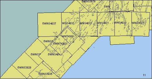
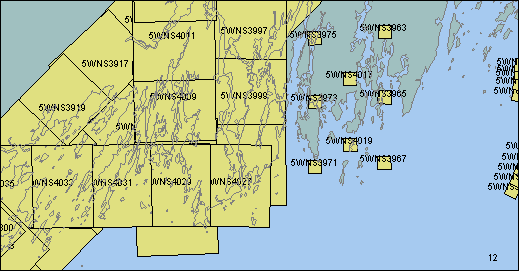
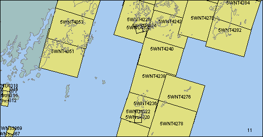
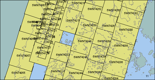
Clicking on a photo ID link will open the photo in a new browser window. Clicking on another photo ID link will will open that photo in the browser window of the previous photo. This way you can set the browser windows (index and photo) side-by-side for easier viewing. The photos are GIF files about 900x900 pixels and about 500-800 kb in size. Scales vary as noted in the table. Resolution is 100 dpi from a 9x9" film. Photos with a scale of 40,000 cover an area about 5.5 miles square at about 150 pixels/mile. North is not always at the top of the photo. Most Photos are oriented so north is at top (roughly), some are not. I think the "Azimuth" column represents the bearing of the sun from the aircraft when the photo was taken (important to air photo interpreters). The coordinates given for the photo appear to be for the center but I have found some where the coordinates are not even a point within the photo. See this page on the NOS web site for a description of the coastal air photos: http://oceanservice.noaa.gov/mapfinder/products/photos/welcome.html |

| Image ID | Year | Scale | Azimuth | Latitude | Longitude | |
| 5WNS3913 | 1998 | 49400 | 224.8 | 43.9904 | -69.8603 | |
| 5WNS3915 | 1998 | 49600 | 223.5 | 43.9400 | -69.9274 | |
| 5WNS3917 | 1998 | 49500 | 226.6 | 43.8890 | -69.9962 | |
| 5WNS3919 | 1998 | 49400 | 224.2 | 43.8374 | -70.0659 | |
| 5WNS3921 | 1998 | 49500 | 224.0 | 43.7838 | -70.1377 | |
| 5WNS3939 | 1998 | 49300 | 043.4 | 43.6523 | -70.1580 | |
| 5WNS3941 | 1998 | 49400 | 043.2 | 43.7066 | -70.0878 | |
| 5WNS3943 | 1998 | 49500 | 042.4 | 43.7613 | -70.0150 | |
| 5WNS3945 | 1998 | 49400 | 045.8 | 43.8155 | -69.9419 | Quahog Bay |
| 5WNS3947 | 1998 | 49400 | 044.3 | 43.8712 | -69.8678 | |
| 5WNS3949 | 1998 | 49600 | 042.7 | 43.9265 | -69.7930 | |
| 5WNS3951 | 1998 | 49600 | 043.5 | 43.9807 | -69.7206 | |
| 5WNS3963 | 1998 | 8000 | 180.4 | 43.9307 | -69.5445 | |
| 5WNS3965 | 1998 | 8000 | 180.4 | 43.8540 | -69.5449 | |
| 5WNS3967 | 1998 | 8000 | 179.3 | 43.7775 | -69.5453 | |
| 5WNS3971 | 1998 | 8000 | 000.2 | 43.7728 | -69.6575 | |
| 5WNS3973 | 1998 | 8000 | 000.8 | 43.8489 | -69.6575 | |
| 5WNS3975 | 1998 | 8000 | 356.7 | 43.9234 | -69.6587 | |
| 5WNS3995 | 1998 | 49100 | 179.6 | 44.0046 | -69.7716 | |
| 5WNS3997 | 1998 | 49400 | 179.9 | 43.9280 | -69.7711 | |
| 5WNS3999 | 1998 | 49400 | 180.4 | 43.8514 | -69.7713 | |
| 5WNS4001 | 1998 | 49400 | 179.5 | 43.7745 | -69.7713 | |
| 5WNS4005 | 1998 | 49300 | 357.6 | 43.7171 | -69.8833 | |
| 5WNS4007 | 1998 | 49500 | 001.9 | 43.7831 | -69.8853 | |
| 5WNS4009 | 1998 | 49500 | 358.3 | 43.8500 | -69.8859 | |
| 5WNS4011 | 1998 | 49500 | 359.1 | 43.9216 | -69.8870 | |
| 5WNS4013 | 1998 | 49500 | 359.1 | 43.9907 | -69.8861 | |
| 5WNS4017 | 1998 | 8000 | 179.3 | 43.8757 | -69.6005 | Damariscotta River with East Boothbay, South Bristol |
| 5WNS4019 | 1998 | 8000 | 179.9 | 43.7986 | -69.6004 | Southport Island, Squirrel Island, Fisherman's Island Passage, Damariscotta River mouth |
| 5WNS4027 | 1998 | 49700 | 271.6 | 43.7506 | -69.7967 | |
| 5WNS4029 | 1998 | 49700 | 269.8 | 43.7509 | -69.8942 | |
| 5WNS4031 | 1998 | 49800 | 269.1 | 43.7497 | -69.9903 |

| Image ID | Year | Scale | Azimuth | Latitude | Longitude | |
| 5WNS3913 | 1998 | 49400 | 224.8 | 43.9904 | -69.8603 | |
| 5WNS3915 | 1998 | 49600 | 223.5 | 43.9400 | -69.9274 | |
| 5WNS3917 | 1998 | 49500 | 226.6 | 43.8890 | -69.9962 | |
| 5WNS3919 | 1998 | 49400 | 224.2 | 43.8374 | -70.0659 | |
| 5WNS3921 | 1998 | 49500 | 224.0 | 43.7838 | -70.1377 | |
| 5WNS3939 | 1998 | 49300 | 043.4 | 43.6523 | -70.1580 | |
| 5WNS3941 | 1998 | 49400 | 043.2 | 43.7066 | -70.0878 | |
| 5WNS3943 | 1998 | 49500 | 042.4 | 43.7613 | -70.0150 | |
| 5WNS3945 | 1998 | 49400 | 045.8 | 43.8155 | -69.9419 | |
| 5WNS3947 | 1998 | 49400 | 044.3 | 43.8712 | -69.8678 | South of Bath (north is to left) |
| 5WNS3949 | 1998 | 49600 | 042.7 | 43.9265 | -69.7930 | Bath (north is to left) |
| 5WNS3951 | 1998 | 49600 | 043.5 | 43.9807 | -69.7206 | |
| 5WNS3963 | 1998 | 8000 | 180.4 | 43.9307 | -69.5445 | |
| 5WNS3965 | 1998 | 8000 | 180.4 | 43.8540 | -69.5449 | Tenants Harbor and west (north is to left) |
| 5WNS3967 | 1998 | 8000 | 179.3 | 43.7775 | -69.5453 | |
| 5WNS3971 | 1998 | 8000 | 000.2 | 43.7728 | -69.6575 | |
| 5WNS3973 | 1998 | 8000 | 000.8 | 43.8489 | -69.6575 | |
| 5WNS3975 | 1998 | 8000 | 356.7 | 43.9234 | -69.6587 | |
| 5WNS3995 | 1998 | 49100 | 179.6 | 44.0046 | -69.7716 | |
| 5WNS3997 | 1998 | 49400 | 179.9 | 43.9280 | -69.7711 | |
| 5WNS3999 | 1998 | 49400 | 180.4 | 43.8514 | -69.7713 | |
| 5WNS4001 | 1998 | 49400 | 179.5 | 43.7745 | -69.7713 | |
| 5WNS4005 | 1998 | 49300 | 357.6 | 43.7171 | -69.8833 | |
| 5WNS4007 | 1998 | 49500 | 001.9 | 43.7831 | -69.8853 | |
| 5WNS4009 | 1998 | 49500 | 358.3 | 43.8500 | -69.8859 | |
| 5WNS4011 | 1998 | 49500 | 359.1 | 43.9216 | -69.8870 | |
| 5WNS4013 | 1998 | 49500 | 359.1 | 43.9907 | -69.8861 | |
| 5WNS4017 | 1998 | 8000 | 179.3 | 43.8757 | -69.6005 | |
| 5WNS4019 | 1998 | 8000 | 179.9 | 43.7986 | -69.6004 | |
| 5WNS4027 | 1998 | 49700 | 271.6 | 43.7506 | -69.7967 | |
| 5WNS4029 | 1998 | 49700 | 269.8 | 43.7509 | -69.8942 | |
| 5WNS4031 | 1998 | 49800 | 269.1 | 43.7497 | -69.9903 | |
| 5WNS4033 | 1998 | 49800 | 269.1 | 43.7494 | -70.0859 |

| Image ID | Year | Scale | Azimuth | Latitude | Longitude |
| 5WNS3881 | 1998 | 8000 | 133.0 | 44.0443 | -68.6683 |
| 5WNS3883 | 1998 | 8000 | 132.8 | 44.0352 | -68.6550 |
| 5WNS3885 | 1998 | 8000 | 133.4 | 44.0268 | -68.6424 |
| 5WNS3887 | 1998 | 8000 | 134.3 | 44.0181 | -68.6300 |
| 5WNS3889 | 1998 | 8000 | 133.7 | 44.0095 | -68.6176 |
| 5WNS3893 | 1998 | 8000 | 000.7 | 44.0030 | -69.1028 |
| 5WNS3895 | 1998 | 8000 | 001.7 | 44.0161 | -69.1026 |
| 5WNS3897 | 1998 | 8000 | 006.2 | 44.0283 | -69.1015 |
| 5WNS3899 | 1998 | 8000 | 006.5 | 44.0406 | -69.0995 |
| 5WNT4051 | 1998 | 48000 | 015.0 | 43.9711 | -69.1401 |
| 5WNT4053 | 1998 | 48000 | 015.3 | 44.0390 | -69.1119 |
| 5WNT4055 | 1998 | 48000 | 017.8 | 44.1058 | -69.0832 |
| 5WNT4224 | 1998 | 48000 | 197.1 | 44.1108 | -68.8693 |
| 5WNT4226 | 1998 | 48000 | 197.3 | 44.0451 | -68.8970 |
| 5WNT4234 | 1998 | 48000 | 015.0 | 43.8104 | -68.8908 |
| 5WNT4236 | 1998 | 48000 | 019.1 | 43.8501 | -68.8750 |
| 5WNT4238 | 1998 | 48000 | 015.5 | 43.9131 | -68.8484 |
| 5WNT4240 | 1998 | 48000 | 015.7 | 43.9768 | -68.8222 |
| 5WNT4242 | 1998 | 48000 | 016.9 | 44.0397 | -68.7958 |
| 5WNT4244 | 1998 | 48000 | 015.7 | 44.1037 | -68.7721 |
| 5WNT4268 | 1998 | 48000 | 196.3 | 44.1078 | -68.6671 |
| 5WNT4270 | 1998 | 48000 | 195.8 | 44.0478 | -68.6914 |
| 5WNT4276 | 1998 | 48000 | 197.1 | 43.8656 | -68.7662 |
| 5WNT4278 | 1998 | 48000 | 197.0 | 43.8040 | -68.7914 |
| 5WNT4282 | 1998 | 48000 | 015.3 | 44.0197 | -68.6050 |
| 5WNT4284 | 1998 | 48000 | 017.9 | 44.0835 | -68.5785 |
| 5WNU4320 | 1998 | 8000 | 000.6 | 43.8187 | -68.9000 |
| 5WNU4322 | 1998 | 8000 | 004.9 | 43.8315 | -68.8985 |
| 5WNU4324 | 1998 | 8000 | 250.7 | 44.0300 | -68.8792 |
| 5WNU4326 | 1998 | 8000 | 254.1 | 44.0261 | -68.8972 |

| Image ID | Year | Scale | Azimuth | Latitude | Longitude |
| 5WNT4053 | 1998 | 48000 | 015.3 | 44.0390 | -69.1119 |
| 5WNT4055 | 1998 | 48000 | 017.8 | 44.1058 | -69.0832 |
| 5WNT4057 | 1998 | 48000 | 017.5 | 44.1723 | -69.0557 |
| 5WNT4059 | 1998 | 48000 | 016.2 | 44.2388 | -69.0278 |
| 5WNT4061 | 1998 | 48000 | 016.6 | 44.3059 | -68.9980 |
| 5WNT4063 | 1998 | 48000 | 018.6 | 44.3721 | -68.9712 |
| 5WNT4065 | 1998 | 48000 | 016.0 | 44.4369 | -68.9403 |
| 5WNT4091 | 1998 | 48000 | 196.9 | 44.3886 | -68.8577 |
| 5WNT4093 | 1998 | 48000 | 198.2 | 44.3174 | -68.8894 |
| 5WNT4095 | 1998 | 48000 | 197.6 | 44.2458 | -68.9212 |
| 5WNT4097 | 1998 | 48000 | 197.0 | 44.1863 | -68.9464 |
| 5WNT4111 | 1998 | 15000 | 198.4 | 44.3845 | -68.8608 |
| 5WNT4113 | 1998 | 15000 | 197.5 | 44.3612 | -68.8718 |
| 5WNT4115 | 1998 | 15000 | 197.2 | 44.3387 | -68.8813 |
| 5WNT4117 | 1998 | 15000 | 197.8 | 44.3163 | -68.8909 |
| 5WNT4119 | 1998 | 15000 | 197.6 | 44.2940 | -68.9013 |
| 5WNT4121 | 1998 | 15000 | 198.8 | 44.2716 | -68.9112 |
| 5WNT4123 | 1998 | 15000 | 197.8 | 44.2490 | -68.9217 |
| 5WNT4125 | 1998 | 15000 | 199.2 | 44.2266 | -68.9323 |
| 5WNT4127 | 1998 | 15000 | 198.2 | 44.2041 | -68.9433 |
| 5WNT4129 | 1998 | 15000 | 195.9 | 44.1818 | -68.9533 |
| 5WNT4139 | 1998 | 15000 | 018.5 | 44.2406 | -68.9637 |
| 5WNT4141 | 1998 | 15000 | 016.7 | 44.2614 | -68.9546 |
| 5WNT4143 | 1998 | 15000 | 019.2 | 44.2784 | -68.9470 |
| 5WNT4145 | 1998 | 15000 | 017.3 | 44.2970 | -68.9382 |
| 5WNT4147 | 1998 | 15000 | 017.1 | 44.3170 | -68.9298 |
| 5WNT4149 | 1998 | 15000 | 020.4 | 44.3362 | -68.9208 |
| 5WNT4151 | 1998 | 15000 | 018.4 | 44.3560 | -68.9106 |
| 5WNT4153 | 1998 | 15000 | 016.5 | 44.3761 | -68.9019 |
| 5WNT4155 | 1998 | 15000 | 019.2 | 44.3964 | -68.8930 |
| 5WNT4214 | 1998 | 48000 | 196.0 | 44.4435 | -68.7278 |
| 5WNT4216 | 1998 | 48000 | 196.8 | 44.3798 | -68.7554 |
| 5WNT4218 | 1998 | 48000 | 196.3 | 44.3114 | -68.7849 |
| 5WNT4222 | 1998 | 48000 | 196.5 | 44.1765 | -68.8418 |
| 5WNT4224 | 1998 | 48000 | 197.1 | 44.1108 | -68.8693 |
| 5WNT4226 | 1998 | 48000 | 197.3 | 44.0451 | -68.8970 |
| 5WNT4242 | 1998 | 48000 | 016.9 | 44.0397 | -68.7958 |
| 5WNT4244 | 1998 | 48000 | 015.7 | 44.1037 | -68.7721 |
| 5WNT4246 | 1998 | 48000 | 015.6 | 44.1667 | -68.7456 |
| 5WNT4248 | 1998 | 48000 | 016.1 | 44.2297 | -68.7227 |
| 5WNT4250 | 1998 | 48000 | 016.2 | 44.2924 | -68.6951 |
| 5WNT4252 | 1998 | 48000 | 017.6 | 44.3563 | -68.6701 |
| 5WNT4254 | 1998 | 48000 | 015.4 | 44.4190 | -68.6421 |
| 5WNT4258 | 1998 | 48000 | 194.3 | 44.4223 | -68.5365 |
| 5WNT4260 | 1998 | 48000 | 196.2 | 44.3515 | -68.5653 |
| 5WNT4262 | 1998 | 48000 | 195.7 | 44.2902 | -68.5905 |
| 5WNT4264 | 1998 | 48000 | 196.6 | 44.2300 | -68.6155 |
| 5WNT4266 | 1998 | 48000 | 197.1 | 44.1688 | -68.6412 |
| 5WNT4268 | 1998 | 48000 | 196.3 | 44.1078 | -68.6671 |
| 5WNT4270 | 1998 | 48000 | 195.8 | 44.0478 | -68.6914 |
| 5WNT4284 | 1998 | 48000 | 017.9 | 44.0835 | -68.5785 |
| 5WNT4286 | 1998 | 48000 | 015.2 | 44.1473 | -68.5529 |
| 5WNT4288 | 1998 | 48000 | 017.9 | 44.2123 | -68.5247 |
| 5WNT4290 | 1998 | 48000 | 015.9 | 44.2751 | -68.4995 |
| 5WNT4292 | 1998 | 48000 | 017.0 | 44.3399 | -68.4710 |
| 5WNT4294 | 1998 | 48000 | 018.0 | 44.4034 | -68.4448 |
| 5WNU4330 | 1998 | 8000 | 006.9 | 44.2911 | -68.9748 |
| 5WNU4332 | 1998 | 8000 | 006.8 | 44.3052 | -68.9724 |