 All Maps
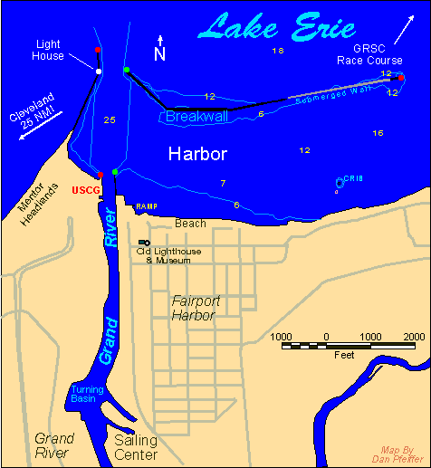
All of the maps on the map page started out as CAD drawings. I digitized the features from USGS and NOAA source maps then imported the data to a drawing program (via a DXF file) to shade areas and add labeling. I find the drawing programs are better at shading, coloring and labeling then the CAD programs. CAD is better at precision drawing and digitizing. That's why I use both. My CAD program is DesignCAD and my drawing program is Corel Draw!. The one exception is the Cleveland area map I made for the GRSC home page. This map was created using Maptitude mapping software which included all of the street and boundry data. I set the map up then did a screen capture to create the GIF file. The version of Maptitude I used did not have good facilities for outputting the maps to image files. After I had the image file I used Corel Photo Paint to tweek the image and drop in some lables and the GRSC logo. I also had to correct some of the roads because the Maptitude data (based on US Census TIGER files) showed road connections incorrectly.
All Maps
All of the maps on the map page started out as CAD drawings. I digitized the features from USGS and NOAA source maps then imported the data to a drawing program (via a DXF file) to shade areas and add labeling. I find the drawing programs are better at shading, coloring and labeling then the CAD programs. CAD is better at precision drawing and digitizing. That's why I use both. My CAD program is DesignCAD and my drawing program is Corel Draw!. The one exception is the Cleveland area map I made for the GRSC home page. This map was created using Maptitude mapping software which included all of the street and boundry data. I set the map up then did a screen capture to create the GIF file. The version of Maptitude I used did not have good facilities for outputting the maps to image files. After I had the image file I used Corel Photo Paint to tweek the image and drop in some lables and the GRSC logo. I also had to correct some of the roads because the Maptitude data (based on US Census TIGER files) showed road connections incorrectly.
 Track Log Maps
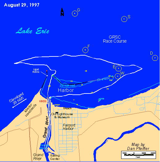
T  N41 46.3785 W081 16.7845 Sun Aug 31 23:18:36 1997
T  N41 46.4168 W081 16.7938 Sun Aug 31 23:19:57 1997
T  N41 46.4461 W081 16.8196 Sun Aug 31 23:21:02 1997
I then bring this data into an Excel spread sheet that I have set up to convert the lat & long to xy coordinates. The xy coordinates are relative to the Fairport Harbor light house for my local maps. I save the xy coodinates to another text file and import that to DesignCAD. I then overlay that on a drawing of the harbor and shoreline using the lighthouse position as the origin reference.
The next step is to export the map to a DXF file and import the DXF file to Corel Draw!. This is where I do the color fills and titles. Drawing programs are better at this then CAD programs. Once I have all the lables and color fills set up I export the drawing as a GIF file and it's ready for the web page. That's how I do it for now. I plan to write a program to convert the track log file directly to the XY file or maybe straight to CAD.